

Chapters
In ancient times, the inhabitants of a given country (city) considered their land to be the centre of the world, having the form of a flat disk. Moreover, according to them, the ends of the world were inhabited by mysterious beings and barbarians who were a threat to the civilized world.
In Mesopotamia, the earth was shown in the shape of a circle, which was surrounded by an ocean full of islands with amazing wonders and wonders. According to the Babylonians, Babylon was the centre of the universe – the so-called itsiggurat. Egyptians, Phoenicians, Hittites and Jews had similar views on the image of the world. Everyone believed that they were in the centre of the world and that the ends of the disk were inhabited by unknown beings.

In Greek myths, Heracles met Amazons, Hesperides or the monster Gerion at the end of the world. The famous Delphi was supposed to be in the place where two eagles released by Zeus from two ends of the world met. To commemorate this fact, a monument omphalos(“navel”), in the shape of a semicircular stone, was erected.
The Greeks also introduced a division into the civilized and barbaric worlds. Originally the word barbaros meant “chatter” or “chatterbox” which was used to describe a person who did not speak Greek. After defeating the Persians in the war in 492-479 BCE, this expression took on a negative tone. The barbarians have gotten worse than the civilized Greeks.
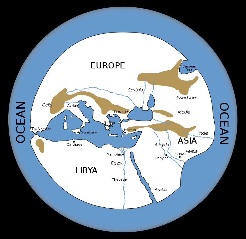
By the end of the 6th century BCE, the world had already taken shape, according to the Greeks. Greece was in the center of the world, surrounded by the Mediterranean Sea (with large islands such as Sicily, Italy and Cyprus); This sea, in turn, was surrounded by three continents, which in turn were encircled by the great Ocean. The ocean was inhabited by bizarre creatures and monsters; the shores of continents, in turn, are the lands where the barbarians lived.
The Greeks understood the schematic nature of their vision of the world, and from the 5th century on, they gradually refined the world map. They did it mainly due to the conquests of Alexander the Great, thanks to which geographic knowledge was expanded. Nevertheless, the pejorative view of other nations and peoples was still present. This idea was later adopted by the ancient Romans.
Below are some visions of the world according to ancient geographers and scientists and their descriptions.
Anaximander of Miletus
Anaximander (c. 610 – c. 546 BCE) was a Greek philosopher and scientist. According to Strabo’s message, he was the creator of the first world map. It is suspected that the main reason for the map was to improve navigation and trade between the Miletus colonies and other centres in the Mediterranean and the Black Sea. The map was distinguished by three continents, two seas and two major rivers that reached the ocean besieging the world. The Aegean Sea was the centre of the world.

Hekataeus of Miletus
The first researcher who departed from a schematic approach to the world was the Greek Hekataeus of Miletus (c. 550 – c. 490 BCE), author of the work Ges Periodos. His vision of the world, however, was not very perfect: Asia was very small compared to the size we know, and the Greek still insisted that the world was flat with its own ends. It is believed that the work of Anaximander was the inspiration for the creation of the map. Strabo considered both of them among the first geographers. In his work, Hekataeus also describes the peoples and lands inhabiting given lands.
Herodotus of Halicarnassus
The second Greek explorer was Herodotus of Halicarnassus (c. 480 – c. 429 BCE), who is called the father of geography. Herodotus was a great traveller; visited, among others Egypt, Babylon, Greece, Italy, Macedonia and the Black Sea coasts. Herodotus was a unique traveller at that time who conducted a kind of research and reportage, honestly describing the visited land. He criticized Hekataeus for showing the ocean circling the world in the form of an ideal circle. However, he also made mistakes by placing civilized Greeks in the center of the world, and barbarians on the fringes. However, it cannot be denied that his map was much more accurate and showed the ancient world he knew (gr. oecumene).

Ctesias
The Greek Ctesias (after 440 – after 380 BCE) was a doctor and historian. In his monograph “About India” (Indica) he described barbarians from distant lands through the eyes of Persians. He used different terms for them: people with dogs’ heads (cynoscephalae), people with one big leg, a creature with a human face and three rows of teeth (Martichora), people with goat legs, midgets, bald, yellow-skinned, blacks, werewolves, naked. As you can see, some of the phenomena described are consistent; most of it, however, is only imagination, which was related to the passed myths.

Eratosthenes
Eratosthenes (276-194 BCE) was a Greek geographer and scientist. He believed, inter alia, that by crossing the Pillars of Heracles (Gibraltar) you would reach India. Based on the information obtained more or less a hundred years earlier during the expedition of Alexander of Macedon to the east, he improved the well-known map of the world, incl. adapted the more correct sizes of continents.
Strabo
The famous Greek geographer Strabo (ca. 63 BCE – ca. CE 24) presented a different vision of the world. His most important work is Geographica, numbering 17 books, which shows the history of peoples and places from different parts of the world. Strabo was also a traveller; clearly stated that he visited, among others Etruria in Italy whether it reached the borders of Ethiopia. In a way, Strabo boasts that he has visited the most places in the world among the famous geographers. In his main work, however, he also relied on treaties that were kept in the library in Alexandria.
Politically, Strabo supported the Roman empire, and in the first place, he distinguished the civilized world (Greece and Rome), which he felt existed in coastal and riverside areas. The Greco-Roman world could cultivate the land, there was no shortage of food, and the diet was varied. Barbarians, in turn, lived in forests and by fjords, which forced them to live a nomadic lifestyle, hunting and breeding. Civilized people lived in cities (Aristotle referred to them as “city-dwelling animals”1), which kept them safe and allowed them to focus on study and rest. Barbarians, in turn, always had to be vigilant, defend their animals, move around.
Barbarians have no (unlike civilized) jobs and habits of behaviour. They have no culture and are out of fashion – they wear stubble, pants and a loose hairstyle. They live in a vicious circle because even if they try to start farming, some jealous neighbour will destroy it. They are also susceptible to manipulation
Strabo also did not avoid the description of fauna, incl. in India, small flying reptiles, about 90 cm long, with the body of a snake and bat wings, had to live. Similar creatures were described by Herodotus or Josephus Flavius .

Pytheas of Massalia

Pytheas of Massalia (who lived in the 4th century BCE) was a great Greek traveller and geographer. Around 310 BCE, he travelled north. Overcoming the fear exacerbated by the Phoenicians’ tales of the atrocities lurking behind Gibraltar, he set sail for the waters of the Atlantic Ocean. Sailing mostly at night (he avoided the Phoenician warships controlling these waters) along the shores of what is now Portugal, Spain and France, he reached the shores of the Great Britain he has circumnavigated, Ireland, and the Shetland Islands, as well as possibly further to Iceland, which is today accepted by most scholars as to the most likely site of the Ultima Thulehe described. It also reached the mouth of the Elbe and left the first news of Germans.
His observations of the frozen sea, whereas he wrote – there is no longer a difference between land and sea and air, and the substance connecting everything cannot be travelled on foot or by ship, have been interpreted by Fridtjof Nansen as a description of ice porridge which in the fog at the shores of drifting ice it may actually look like that. This last segment of sailing was an exceptionally bold undertaking, as it required to venture into the open ocean (so far sailed mainly along the shores), previously unknown. He is considered to be the first daredevil in the history of discoveries who dared, for a purely cognitive purpose, to go out into the open ocean.
Pytheas’ ship was probably 45 m long, up to 7.6 m wide and with a draft of approx. 3 m. The crew consisted of 50-60 rowers and 16-20 sailors for the rudder and sails. It was probably a better built and larger ship than Christopher Columbus’s Santa Maria.

Pytheas’ descriptions were so shocking to his contemporaries that many ancient authors (Strabo among them) ridiculed his accounts of enormous tides of 19 hours of days and the conditions of sailing among the ice.
According to some researchers, Pyteas entered the Baltic Sea and reached the mouth of the Vistula. The basis here is the interpretation of a fragment of the “Natural History” by Pliny the Elder:
Pytheas says that the Gutones, a people of Germany, inhabit the shores of an æstuary of the Ocean called Mentonomon, their territory extending a distance of six thousand stadia; that, at one day’s sail from this territory, is the Isle of Abalus, upon the shores of which, amber is thrown up by the waves in spring, it being an excretion of the sea in a concrete form; as, also, that the inhabitants use this amber by way of fuel, and sell it to their neighbours.
– Pliny the Elder, Natural History, XXXVII.11
His work “On the Ocean” (Perí Okeanu) has survived in fragments to our times.
In the 1st century CE, the sight of Pytheas of Massalia was confirmed by the Roman researcher Pliny the Elder.
Pomponius Mela
Pomponius Mela lived in the middle of the 1st century CE. This one of the first Roman geographers divided the world into five zones, where he only designated two that are inhabited. The others are separated by areas of extremely high temperature and impossible to cross by humans. Pomponius also distinguishes peoples living in the antipodes, regions on opposite sides of the Earth.
Pliny the Elder
Pliny the Elder (23-79 CE) was a Roman historian, writer, philosopher of nature and a fleet commander. His only surviving work is “Natural History”, a kind of encyclopedia, which is a mine of knowledge and ideas in Roman times. He was a good friend of Emperor Vespasian on a daily basis.
The only surviving work is “Natural History” (Naturalis Historia), a kind of encyclopedia in 37 books. It is a mine of knowledge and ideas in Roman times. Information about northern Europe was taken from the treatise of Pytheas of Massalia “On the Ocean”. The encyclopedia is organized not according to entries, but by sections.
Pliny included about 20,000 information from all areas of knowledge at the time – a description of the world, celestial bodies, meteorological phenomena, as well as geography, ethnology, anthropology, physiology, psychology, zoology and anatomy, botany, horticulture, agriculture, herbal and animal medicines, metallurgy, mineralogy, gold, silver, gem processing, medicine, painting, sculpture, etc.
Pliny claimed that he used the works of 327 Greek writers and 146 Latin writers to compose “Natural History”, and that he had studied about 2,000 volumes.
Selected books of “Natural History” tell about the world and the peoples that inhabit it. In Book III we get to know the Iberian Peninsula and Italy; Book IV is a description of Europe along with Britain; Book V Africa and Aasia; Book VI The Black Sea, India, and the Far East.
Marinos of Tire
Marinos of Tire (2nd century CE) was a Roman geographer who first defined countries and some localities by latitude and longitude. He also included China in his world map. He believed that the inhabited world in the west was bordered by the Happy Isles – a place where the dead after a successful life rested. Marinus was also of the opinion that the ocean surrounding the world is divided into its eastern and western parts by continents (Europe, Asia and Africa). Marinus also coined the term Antarctica, referring to the opposite of the Arctic Circle.
Claudius Ptolemy
Claudius Ptolemy (c. 100 – c. 168 CE) was a Greek astronomer, mathematician, and geographer.
Ptolemy treated geography as the science of representing the Earth with a drawing. Thanks to his astronomical preparation, however, he gave it a mathematical dimension. He was familiar with the spherical shape of the Earth and used the projection of the sphere’s surface onto a plane for his maps. However, after Poseidonius of Rhodes, he adopted an incorrect calculation of the length of the geographic degree, which made him unable to avoid considerable inaccuracies in his work. The Ptolemaic definition of latitude is still valid today.
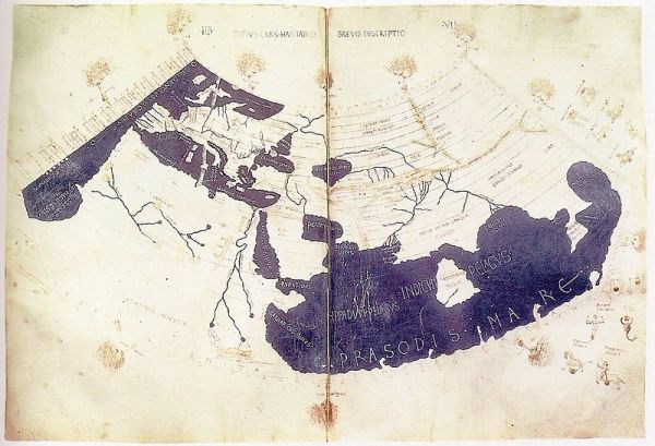
Geography (Geographike Hyphegesis– “Introduction to mapping”) also known as “Geography”, was an attempt to create a map of the world known to him as accurately as possible. It consists of eight books. The first is a theoretical introduction intended to enable the reader to recreate the plans himself, if necessary. Books II to VII contain the names of places and characteristic geographical points (about 8,000 toponyms) with coordinates. What is interesting in Book II. the lands from the Danube to the Baltic Sea, the author mentioned, among others Budorgis later identified with Brzeg, Kalisia identified with Kalisz, Karrodunon associated with Krakow or Askaukalis identified with Bydgoszcz. Book VIII lists the most important cities with more precise coordinates. There were 26 maps attached to the books.
Itinerarium – Roman Roadmap
Itinerarium (literally “journey”) was a Roman map showing cities, smaller centres (vici), and other places of interest to travellers. The only preserved map of this type is the so-called Tabula Peutingerianaor Itinerarium Antonini Augusti.
The Tabula Peutingeriana3is a 13th-century copy of a Roman original that shows Europe (excluding the Iberian Peninsula and the British Isles), North Africa, the Middle East, Persia and India. Scientists suspect that the Roman original was from the 4th-5th centuries, which in turn was a copy of a great map made during the reign of Octavian August (27 BCE – 14 CE).


