Order Total (1 Item Items):
Shipping Destination:

Zeelandia: Maps (21 results)
Skip to main search results
Product Type Clear
- All Product Types
- Books (39)
- Magazines & Periodicals
- Comics
- Sheet Music
- Art, Prints & Posters (10)
- Photographs
- Maps (21)
-
Manuscripts &
Paper Collectibles (15)
Condition
- All Conditions
- New
- Used
Binding
- All Bindings
- Hardcover
- Softcover
Collectible Attributes
- First Edition
- Signed
- Dust Jacket
- Seller-Supplied Images
- Not Printed On Demand
Seller Location
Seller Rating
-
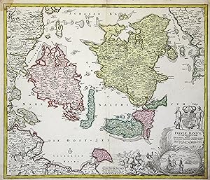
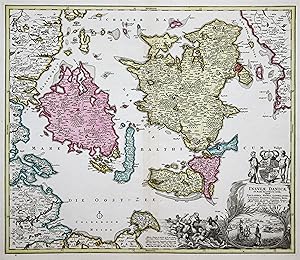
Insulae Danicae in Mari Balthico Sitae utpote Zeelandia, Fionia, Langelandia, Lalandia, Falstria, Fembria Mona
Published by Nuremberg, 1789
Seller: Robert Frew Ltd. ABA ILAB, London, United Kingdom
Association Member: ABA ILAB PBFA
Seller Rating:

Map
Double page (49 x 57 cm.) engraved map with original hand-colour. Some dampstaining.
-

Insulae Danicae in mare Baltico sitae utpote Zeelandia, Fionia, Langelandia, Lalandia, Falstria, Fembria Mona" - D�nemark Denmark Danmark Fyn Sjaelland Falster Lolland islands island
Published by N�rnberg ca. 1720., 1720
Seller: Antiquariat Steffen V�lkel GmbH, Seubersdorf, Germany
Seller Rating:
Map
Altkolorierte Kupferstich-Karte von ca. 1720 - Blatt-Format: ca. 53 x 60 cm - im unteren Mittelbug etwas hinterlegt, rechte untere Au�enecke etwas anger�ndert, sonst gut erhalten. | Old colored copper engraved map from about 1720 - somewhat deposited on the lower part of the centerfold, the right outer corner somewhat deposited, otherwise in good condition. la Gewicht in Gramm: 35.
-
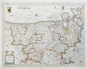
Flandria et Zeelandia comitatus. Kupferstich-Karte aus Matth�us Merian "Neuwe Archontologia cosmica". Frankfurt a. M. 1646, 26 x 34 cm
Seller: Antiquariat Johannes M�ller, Salzburg, Austria
Seller Rating:
Map
# Engraved map from M. Merian's "Neuwe Archontologia cosmica".
-
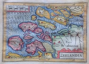
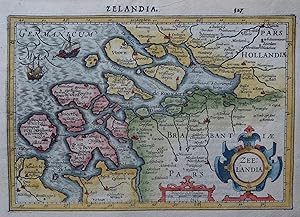
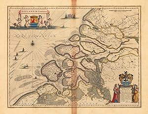
Zeelandia
Published by Willem Jansz. Blaeu, 1635
Seller: Antiquariaat Dat Narrenschip, Middelburg, Netherlands
Seller Rating:
Map
No Binding. Condition: Fine. Titel in cartouche rechts onder; schaalstok in kader links boven. Rugzijde blank. Handgekleurde kopergravure, uitgegeven in 1635 te Amsterdam door Willem Jansz. Blaeu in "Belgic� Sive Inferioris Germani�, Descriptio," Lodovico Guicciardini. Afmetingen (afbeelding): 9 x 13 cm.
-
mit altem Fl�chenkolorit, vor 1729, 49 x 57,5 Unten rechts die Titelkartusche, zusammen mit der kleinen Vogelschauansicht des Sundes.
-
mit altem Fl�chenkolorit, nach 1730, 49 x 57,5 Unten rechts die Titelkartusche, zusammen mit der kleinen Vogelschauansicht des Sundes. - Mit Druckprivileg.
-
Kupferstich- Karte, n. J. Blaeu, "Zeelandia Insvla Danicarum Maxima".
Seller: Antiquariat Clemens Paulusch GmbH, Berlin, Germany
Seller Rating:
Map
mit altem Fl�chenkolorit, um 1690, 43 x 53 Mit 3 Kartuschen, teilweise ausgemalt.- Zeigt die Insel Seeland, eingeteilt in ihre Bezirke.
-
Flandria et Zeelandia Comitatus" - Vlaanderen Zeeland Flandre Ghent Brugge Antwerpen Bruxelles Leuven Kartrijk Belgique Belgium Belgien
Published by Amsterdam ca. 1640., 1640
Seller: Antiquariat Steffen V�lkel GmbH, Seubersdorf, Germany
Seller Rating:
Map
Gro�e altkolorierte Kupferstich-Karte von ca. 1640. -- Mit lateinischem Text auf der R�ckseite. -- Blatt-Ma�e: ca. 50 x 59 cm. -- im Mittelbug etwas hinterlegt, sonst gut erhalten. || Large old colored map from ca. 1640. With Latin text on verso. -- somewhat deposited on the centerfold, otherwise in good condition. || Dies ist ein Original! - Kein Nachdruck! - Keine Kopie! -- This is an original! - No copy! - No reprint! la.
-
ZEELANDIA
Published by Jodocus Hondius, 1610
Seller: Antiquariaat Dat Narrenschip, Middelburg, Netherlands
Seller Rating:
Map
No Binding. Condition: Fine. Oude, antieke landkaart van het graafschap Zeeland. Titel in rolwerkcartouche rechts onder. Links daarvan schaalstok in bescheiden rolwerkcartouche. Rugzijde Latijnse tekst. Handgekleurde kopergravure, uitgegeven te Amsterdam in 1610 door Jodocus Hondius en Cornelis Claesz. in "Atlas Minor Gerardo Mercatoris.".
-
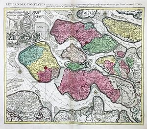
Zeelandia Comitatus novi�ima et accurati�ima delineatione mappa Geographica" - Zeeland Middelburg Vlissingen Goes Zierickzee Bergen op Zoom Holland Nederland Netherlands Niederlande
Published by Augsburg, Tobias Konrad Lotter ca. 1760., 1760
Seller: Antiquariat Steffen V�lkel GmbH, Seubersdorf, Germany
Seller Rating:
Map
Seltene altkolorierte Kupferstich-Karte von ca. 1760. --Blatt-Ma�e: ca. 54,5 x 65 cm. -- sehr gut erhalten. || Rare old colored engraved map from c. 1760. -- in very good condition. || Dies ist ein Original! - Kein Nachdruck! - Keine Kopie! -- This is an original! No copy! - No reprint! la Gewicht in Gramm: 30.
-
mit altem Fl�chenkolorit, nach 1730, 49 x 57,5 Unten rechts die Titelkartusche, zusammen mit der kleinen Vogelschauansicht des Sundes. - Mit Druckprivileg und besonders sch�nem Kolorit. ( Ausgabe bei Ottens ?).
-
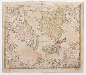
Zeelandia Insula Danicarum Maxima [Zealand (Seeland / Sj�lland), the largest island of Denmark]
Publication Date: 1667
Map
Condition: Fair-to-Good. ZEELANDIA INSULA DANICARUM MAXIMA. Seeland Sj�lland Copenhagen BLAEU c1667 map. Original large folio 17th century antique map with wide margins. Uncoloured; Joan/Johannes Blaeu (c1667). 49.5 x 61.0cm, 19.5 x 24 inches; this is a folding map. Condition: Fair-to-Good: Offsetting - text and/or images from the facing page have left an impression on the print. Please contact us if you would like to arrange to view this map. The text on reverse side, which relates to the map, is printed in Spanish. The Spanish text edition is extremely rare. Other places marked or shown on the map include Kiobenhafven (K�benhavn / Copenhagen), Helsingor, Cronenborg (Cronborg), Koge (K�ge), Faxe, Waringborg (Vordingborg), Praesto, Nestved (Naestved), Kallundborg (Kalundborg), Stubkoping (Stubbekobing).
-
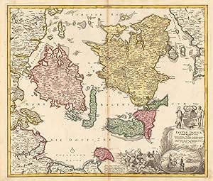
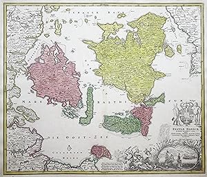
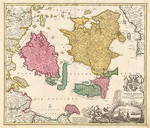
Insulae Danciae in Mari Balthico Sitae, utope Zeelandia, Fiona Langelandia,, Falstria, Fembria Mona repraesentatae et auctae Secundum Geographiam nyissimam IOH. H�BNERI. I. V. L. � IOH: BAPT. HOMANNO.
Published by Homann 1720-40, N�rnberg, 1720
Seller: Antiquariat Reinhold Berg eK Inh. R.Berg, Regensburg, Germany
Seller Rating:

Map
Other. Original antique copper engraving in contemporary hand color in wash and outline when published. Fine hand colored and highly decorative map showing the Danish island in the Baltic Sea: Zeeland, Fionia, Langeland, Laland, Falstria and Fembria Mona based on the cartographic sources by Ioh. H�bner. Ornated with a decorative allegoric title cartouche in the lower right corner. Below with an engraved view of the Sund with sailing boats in the foreground. In excellent condition. 496 by 581mm (19 by 22 inches). 496 by 581mm (19 by 22 inches).
-
Insulae Danciae in Mari Balthico Sitae, utope Zeelandia, Fiona Langelandia, Lalandia, Falstria, Fembria Mona repraesentatae � Ioh. Bapt. Homanno Noribergae.
Published by Homann 1720-40, N�rnberg, 1720
Seller: Antiquariat Reinhold Berg eK Inh. R.Berg, Regensburg, Germany
Seller Rating:
Map
Other. Original antique copper engraving in full contemporary hand color in wash and outline when published. A fine hand colored and highly decorative map showing the Danish islands in the Baltic Sea: Zeeland, Fionia, Langeland, Laland, Falster and Fembria Mona by the famous German cartographer Johann Baptist Homann. Ornated with a decorative allegoric title cartouche in the lower right corner. Below with an engraved view of the Sundt with sailing boats in the foreground. In excellent condition. 492 by 572mm (19 by 22 inches). 492 by 572mm (19 by 22 inches).
-
Zeelandia Comitatus" - Zeeland Middelburg Goes Rotterdam H�lst Steenbergen Nederland Niederlande Netherlands Holland
Published by Amsterdam ca. 1640., 1640
Seller: Antiquariat Steffen V�lkel GmbH, Seubersdorf, Germany
Seller Rating:
Map
Gro�e altkolorierte Kupferstich-Karte von ca. 1640. -- Mit lateinischem Text auf der R�ckseite. -- Blatt-Ma�e: ca. 49,5 x 59 cm. -- gut erhalten. || Large old colored map from c. 1640. With Latin text on verso. -- in good condition. || Dies ist ein Original! - Kein Nachdruck! - Keine Kopie! -- This is an original! - No copy! - No reprint! la.
-
Zeelandia Comitatus" - Zeeland Holland Nederland Netherlands Niederlande
Published by Amsterdam ca. 1700., 1700
Seller: Antiquariat Steffen V�lkel GmbH, Seubersdorf, Germany
Seller Rating:
Map
Altkolorierte Kupferstich-Karte von ca. 1700. -- Blatt-Ma�e: ca. 53 x 61 cm. -- gut erhalten. || Old colored engraved map from ca. 1700. -- in good condition. || Dies ist ein Original! - Kein Nachdruck! - Keine Kopie! -- This is an original! - No copy! - No reprint! la Gewicht in Gramm: 550.
-
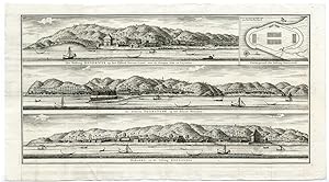
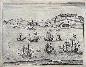
INDONESIA-AMBON-ZEELANDIA-BEVERWIJK-FORT After VALENTIJN-VOC, 1724
Publication Date: 1724
Seller: Pictura Prints, Art & Books, Overasselt, Netherlands
Seller Rating:
Map
No binding. Condition: Good. "De vesting Beverwijk op het eiland Noessa-Laoet ( ). De Fortres Duurstede op het eiland Honimoa ( ). Haroeka en de Vesting Zeelandia ( ).Copperplate engraving/etching on hand laid (verge) paper. Sheet size: 64,2 x 35 cm. Image size: 58 x 29,7 cm. From the monumental work by Fran�ois Valentyn: "Oud en nieuw Oost-Indi�n, vervattende een naaukeurige en uitvoerige verhandelinge van Nederlands mogentheyd in die gewesten". Dordrecht/Amsterdam: J. van Braam en G. onder de Linden, 1724/1726. (Transl.: Old and new East-Indies, including an accurate and extensive description of Dutch / VOC controlled territories.)Made by F. Ottens after Francois Valentijn / VOC sources. Fran�ois Valentijn / Valentyn (1666-1727), was a Dutch minister, naturalist and author. He was send by the VOC as a missionary and mostly worked at Amboina from 1684-1694 and 1705-1713. He traveled extensively in the VOC controlled territories and befriended the German naturalist Georg Eberhard Rumpf (Rumphius). He probably had access to VOC archives and compiled much in this momumental work from others as well. Engraver unknown/to be determined. Condition: Good, given age. Paper separation of two lower folds, expertly repaired. Two sheets joined together as issued. Original folds as issued. General age-related toning and/or occasional minor defects from handling. Please study scan carefully.Keywords: INDONESIA-AMBON-ZEELANDIA-BEVERWIJK-FORTPCOM-A10-25".
-
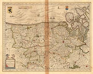
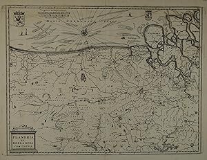
Flandria et Zeelandia comitatus. - Apud. Guiljelmum Blaeuuw.
Published by Blaeu 1643-50, Amsterdam, 1643
Seller: Antiquariat Reinhold Berg eK Inh. R.Berg, Regensburg, Germany
Seller Rating:
Map
Other. Original antique copper engraving, hand colored in outline and wash when published. This antique map shows Flandria and Zeelandia in Belgium. The map is equipped with many place names, rivers, woods, etc. In the lower left corner we see the title cartouche. At the top we look to the mileage scale and two coat of arms of Flandria . In very good to excellent condition. The centre fold is slightly browned. 418 by 530mm (16 by 20 inches). 418 by 530mm (16 by 20 inches).
-
Taiwan Formosa Anping Tainan Fort Zeelandia - I Commelin J Janssonius - 1646
Seller: Antiquariaat Dat Narrenschip, Middelburg, Netherlands
Seller Rating:
Map
Condition: Fine. Oude, antieke prent van Fort Zeelandia op Taiwan. Rugzijde blank.Vroege afbeelding van Fort Zeelandia. De voorstelling dateert uit 1632.Kopergravure, uitgegeven in 1646 te Amsterdam door Johannes Janssonius inBegin ende Voortgangh/ Van De Vereenighde Nederlantsche Geoctroyeerde Oost-Indische Compagnie (.), Isaac Commelin.Hoogte 15,5 cm.; breedte 20 cm.
-
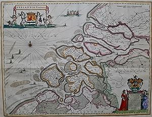
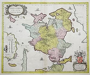
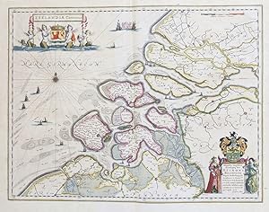
Zeelandia Comitatus
Published by Joan Blaeu, 1662
Seller: Antiquariaat Dat Narrenschip, Middelburg, Netherlands
Seller Rating:
Map
No Binding. Condition: Fine. Oude, antieke landkaart van het graafschap Zeeland. Links boven titelcartouche met wapen van Zeeland. Rechts onder cartouche met opdracht aan S. Bellimontio. In de Noordzee een windroos en diverse schepen. Rugzijde: Latijnse tekst. Oudtijds gekleurde kopergravure, uitgegeven te Amsterdam door Joan Blaeu in 1662 in "Atlas Maior, Sive Cosmographia Blaviana (.)." Afmetingen (afbeelding): 39 x 51 cm.
-
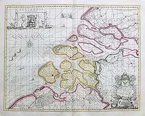
Zeelandia Comitatus
Published by G. Blaeu 1643-50, Amsterdam, 1643
Seller: Antiquariat Reinhold Berg eK Inh. R.Berg, Regensburg, Germany
Seller Rating:
Map
Other. Original antique copper engraving, hand colored in outline published in Joan Blaeu s Atlas Novus . French text edition. This decorative map shows the islands, many sailing ships. The title cartouche is in the lower right corner. In excellent condition. The centrefold has a browning touch. 382 by 500mm (15 by 19 inches). 382 by 500mm (15 by 19 inches).
![Seller image for Zeelandia Insula Danicarum Maxima [Zealand (Seeland / Sj�lland), the largest island of Denmark] for sale by Antiqua Print Gallery](https://pictures.abebooks.com/inventory/md/md31102179026.jpg)